
- Desktop Modeling
- Certainty™
Certainty™
Hot
Updated
Overview
Company Name:
Product Summary:
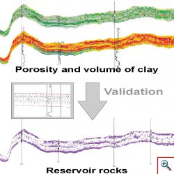
Subsystem Certainty™ is designed for integrated interpretation of cartographic data in combination with well data. It can be used by geologist and geophysicist at all stages of exploration a field development for generating maps of areal zonation, probability of success or predictive layer properties using any number of interval seismic and non seismic attributes. Uncertainty maps are generated simultaneously with predictions.
Product Status:
Commercial
Interested in seeing detailed feature support levels for Certainty™ ? et-3 subscribers can access over 8,000 feature support levels for over 2,000 solutions.
Sign up for et-3 today >
Want to review the product you have used?
Add it now.
User reviews
1 Certainty™ Review
Already have an account? Log in now
Top process and facilities simulator
This is pretty good
Pro's & Con's
User Relationship
Planning to Use
EH


Evander Holyfield
- Category
- Product
Want to review the product you have used?
Add it now.